Major Components of Specific Plan
The City, through numerous workshops, public outreach events and stakeholder meetings, is laying the foundation for the updated Town Center Specific Plan by making critical decisions on elemental components of the Specific Plan, including the project boundary, circulation plan, land use plan, and buildout scenario. These components address the entire Town Center holistically, looking at how different areas of the Town Center, both developed and undeveloped, connect and relate to one another and will provide the building blocks for crafting plans for specific sites within the Town Center. A presentation on these major components and conceptual designs was provided to the City Council on September 13, 2023.
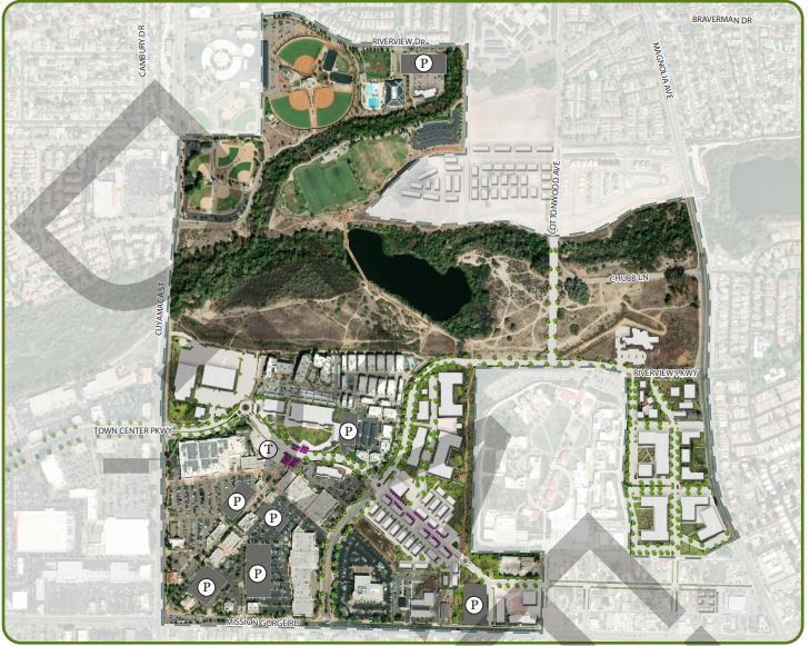
Project Boundary
The revised Town Center Specific Plan would include the Mission Creek Shopping Center, located on the northwest corner of River Park Drive and Cuyamaca Street, which includes Off Broadway Live. Although not included in the Arts & Entertainment District, this shopping center offers the opportunity to support dining and entertainment-oriented businesses as part of the broader vision for the Town Center. In addition, the Mission Gorge Square Shopping Center, on the northwest corner of Mission Gorge Road and Cuyamaca Street, is proposed for inclusion within the updated Town Center Specific Plan. As a result of including these two areas within the updated Town Center Specific Plan, the Town Center area would expand from 609.7 to 651.4 acres, increasing by a total of 41.7 acres.
Circulation Plan
A network of interconnected public streets, trails, and walkways that fosters ease of access by residents and visitors alike to the many uses envisioned for the Town Center is planned for the updated Town Center Specific Plan. The proposed Circulation Plan would provide an internal network of public streets with provisions for on-street parking in order to support the mixed-use developments that are planned for the Town Center. This interconnected internal network of streets and pedestrian pathways would support the concept of “A Day in the Life” of a future resident of the Town Center, where a resident could conduct a majority of their shopping, personal services, and recreating in the Town Center and adjacent areas with convenience, without the stress of being forced to travel onto congested arterial roadways to conduct such activity. Acknowledging that Santee is a car-oriented bedroom community, it is imagined that many future Town Center residents may be future commuters. Provisions for ample on- and off-street parking in the Town Center are being made to ensure that families and individuals are able to access all of the Town Center amenities, but also access the regional vehicular network of roadways. However, it is envisioned the Town Center will support the concept of micromobility, where once a resident is back at home in Town Center for the evening or weekend they can take a stroll to a nearby coffee shop or restaurant from their home, walk to their neighborhood salon, jog along the network of shaded sidewalks, bike along trails linked to the San Diego River, or take a short car trip to a store at Trolley Square without ever having to travel on a major roadway such as Mission Gorge Road. Micromobility is the concept of ease of access and connectivity to different uses within a local geographic area with short trips taken via different (multimodal) modes of transportation, such as walking, biking, ride share services, short vehicle trips, and with assistive mobility devices, including electric scooters and bicycles. The Circulation Plan would also provide nodes where streets, paths and gateways to trails converge that can serve as landmarks, such as the proposed Patriot Point where “main street” meets with a trailhead at a roundabout with a large American flag at the center.
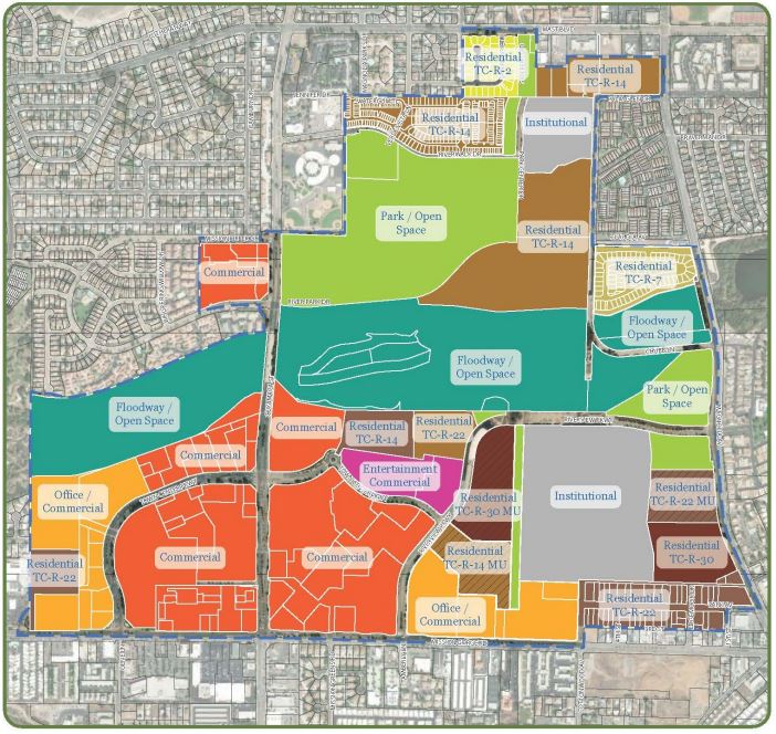
Land Use Plan
As part of this planning effort to update the Town Center Specific Plan, a new Land Use Plan map is proposed. The new Land Use Map would better reflect existing and planned land uses within the Town Center area with colored land use designations. Allowed, conditionally allowed, and expressly prohibited uses corresponding to each land use designation will be further refined with the drafting of the Specific Plan.
Buildout Scenario
The update to the Town Center Specific Plan not only offers an opportunity to envision uses for those undeveloped portions of the Town Center, but also to provide the framework and the necessary environmental clearances to support and streamline future investment in areas of the Town Center that are presently developed. After an assessment of the commercially developed areas of Town Center it was discovered that most of these areas are developed with single-story structures with relatively low-density floor area ratios under 20% or 0.2. The floor area ratio is calculated by dividing the total building square footages by the total square footage of the underlying property. For the Town Center Specific Plan Update buildout scenario, a floor area ratio of 30% or 0.3 has been assumed. This floor area ratio is considered reasonable for commercial development in a suburban community such as Santee. Higher floor area ratios are typically found in much denser urban core areas. With a 0.3 floor area ratio, existing development would have the opportunity for additional investment and revitalization in the future.
Plan Alternatives
Based on the major components listed above, several site specific plan alternatives have been crafted by the City's architectural consultant on the Town Center Specific Plan Update project, M. W. Steele.